Few historical buildings in the world combine mythology and historical theories. One of them is Adam’s Bridge, also known as Ram Setu. Lately, the government has approved underwater exploration to study the structure and age of the Ram Setu and its establishment. This research will also help to understand whether the bridge is as old as the Ramayana period. This makes it more interesting. It would be much more captivating to see if there is any way to combine Indian mythology with modern architecture. Let’s have a look at the mystifying facts of Adam’s Bridge (Ram Setu).
HISTORICAL OVERVIEW: RAM SETU / Adam’s Bridge
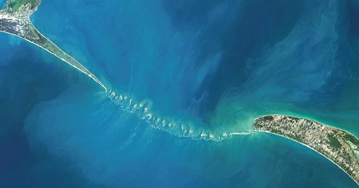
The Adam’s Bridge, or Ram Setu as the Indians call it, is a 48-kilometer-long chain bridge made of limestone coast between Rameswaram on the southeast coast of India and Mannar on the northwest coast of Sri Lanka. In the Indian mythology of Ramayana, the existence of Ram Setu has been discussed, but so far, there is no scientific evidence that it is a bridge. However, it has been noted that people could walk across this bridge until the 15th century. Temple records indicate that Adam’s bridge or Ram Setu was entirely above sea level before 1480. However, natural calamities struck, forcing the so-called bridge to go under the shallow sea. According to Hindu mythology, it was built by a group of monkeys for the Hindu god Ram and his warriors to travel to Lanka to save Sita.
MYSTIFYING FACTS OF RAM SETU (ADAM’S BRIDGE)
- The bridge that separates Mannar Bay from the Palk Strait is estimated to be at least 50kms long. Some shoals are very dry, and the water is very shallow, only 1 to 10 meters deep.
- It is said that the bridge was not accessible until the storm deepened the canal in the 15th century. Few temple records indicate that the Ram Setu or Adam’s Bridge was entirely above sea level until it was destroyed by a hurricane in 1480.
- This bridge first appeared in the Indian epic “Ramayana” by Valmiki. It is believed that Lord Rama’s Vanar Sena (monkey army) was ordered by Nala, the architect, to travel to Lanka and to rescue his wife Sita from Ravana’s clutches. The bridge was built with a pumice stone, and the name of Venerable Rama was engraved on it to make it unsinkable.
- The bridge is now underwater, but in this area, the water is so shallow that it is impossible to navigate.
- Oceanographic research shows that the bridge can be 7,000 years old, which matches the carbon dating of the beaches near Mannar Island.
- The Sethusamudram project is a bridge planned to be built on Palk Straits. The purpose is to enter Mannar Island in Sri Lanka from Pamban Island which is in Tamil Nadu.
MAN-MADE BRIDGE OR HOAX? | SCIENTIFIC FACTS ABOUT RAM SETU
There are many studies that are trying to understand the precise nature of this structure. Raj Bhagat Palanichamy, a remote sensing analyst and a GIS at the World Resource Institute, posted a satellite animation on Twitter explaining the layers formed between India and Sri Lanka. Experts quoted NASA satellite images and other evidence to conclude that the age difference between sand and rock proves that humans must have built the stone bridge. Although environmentalists say this will destabilize aquatic life in the area, some activists question its economic viability.
Sethusamundram is a national marine biosphere reserve to be protected as it is part of the continuous process of natural sedimentation in the ocean. Nature has constantly been doing this for millions of years and has created coral shelves. During the most significant ice age, 22,000 years ago, most of the Indian coast, including parts of Sethusamundram, was exposed to the water.
Some studies have shown that the last sea-level decline occurred between 1,200 and 700 years ago, in a period known as the “Little Ice Age.” As sea levels have soared since then, coral polyps may grow taller on newly submerged shelves. Unsurprisingly, in a dynamic environment like Ram Setu, people have discovered coral rocks that are 7,000 to 4,000 years old, and they are older than young coral rocks.
These shallow sea platforms may have been used in the ocean by different generations of immigrants in the distant past. It is claimed that these stones were shipped from other places, not necessarily human intervention. Carried by cyclones, this is common in the area, not to mention rare tsunamis.
KNOW MORE ABOUT MYSTERIOUS RAM SETU FACTS (ADAM’S BRIDGE)
This bridge first appeared in Ibn Khordadbeh’s “Book of Streets and Kingdoms” (circa 850), where it was called ‘Set Bandhai’ or ‘Sea Bridge.’ Other sources described the bridge as being related to the bridge that Adam crossed from Sri Lanka to India after he was banished from the Garden of Eden, which led to the name Adam’s Bridge. In addition, in 1804, a British cartographer drew the oldest map, calling the area Adam’s Bridge. However, the actual sources of the name are still subject to a lot of speculation.
Sri Lanka is home to a famous mountain, which is considered a holy place for at least four religions: Christianity, Hinduism, Islam, and Buddhism. The top of the 7,360-foot mountain is called Adam’s Peak (the place on earth where the Prophet Adam first set foot) and Sri Pada (a holy footprint left behind by the Buddha). On the other hand, the Hindu faith associates huge footprints with those of Lord Shiva. The peak has an unusual trajectory and measures 5’7″ x 2’6″.
Muslims and Christians believe this is the trace of the prophet Adam. According to the Prophet Muhammad, the Prophet Adam was 60 cubits (90 feet) tall. Many Muslim scholars believe that Adam and Eve descended from the sky together and ascended to the summit of Adam. The momentum with which he landed on the earth was so great that people believed that he made the final blow and left his mark on the rock. The next ground connection with Arabia is through the Indian subcontinent. However, the sea area between Sri Lanka and India is relatively small. But for a great man like the prophet Adam, building a bridge to the Indian continent may not be such a huge success. When he lived for about 1,000 years, it was also difficult. Therefore, believers firmly believe that he must have built this bridge before he can reach the Indian mainland and walk from there to Arabia.
THE GREAT EXPEDITION TO THE BRIDGE
So far, the Indian Council of Historical Research (ICHR) has been on the receiving end of innumerable suggestions regarding the discovery. Although these suggestions have been accepted, this is still being ventured as being their maiden expedition. The Ram Setu was explored during an expedition by the Council of Scientific and Industrial Research (CSIR) and the National Oceanographic Institute (NIO) in the past to see if there are flooded houses around the area. The NIO proposal states: “The historical authenticity and age of Ramayana are still controversial among historians, archaeologists, and scholars. Therefore, studies have to be done to discover the origins of Ram Setu and the areas surrounding them”.
India has a coastline of around 7,500 kilometers or more. The ocean is a treasure trove of prior records: evolutionary changes in marine fauna, coastal life, climate, dwellings, settlements, and civilization. Among them, the changes in sea level are still the most significant. Before the advent of the Global Positioning System (GPS), seafarers made unknown voyages, later discovered new countries and islands, and even ventured into the deep sea, recorded in history. Scientists say that many shipwrecks and remnants of the past can be found. Investigating shipwrecks, cultural relics can provide a wealth of information.
Sindhu Sankalp or Sindhu Sadhana, which are the research ships of NIO, will participate in the project to collect sediment samples 35 to 40 meters below the water level. NIO will conduct an experiment using carbon dating technology to determine the age of the sediments when the archaeological remains were discovered. Similarly, research on underwater exploration will be based on archaeological antiquity, radiometry, and thermo-luminescence dating on geological time scales.
There are two ways of getting this test underway. Firstly is the side-scan sonar, which provides depth similar to checking the terrain of land structures. The acoustic signal is sent to the structure, which provides a schematic diagram of Ram Setu‘s physical structure. Silo seismic survey is another method where weak tremors will be dispatched near the structure, which will resemble a very mild earthquake. These stimulated shock waves can penetrate the structure. The reflected or refracted signal is detected by the instruments that make up the underground structure.
- The research will be based on archaeological antiquity, radiometry, and thermo-luminescence (TL) dating of geological time scales and other supporting environmental data.
- The research will be used to determine the age of the structure reportedly made of coral or pumice stone.
- As historians, archaeologists and scholars are still arguing about the history and date of Ramayana, underwater science and archaeological research will help understand the nature and formation of Ram Setu.
- The study will also reveal whether there are flooded houses in the Ram Setu
- According to official data, the initial budget of the project is INR 10 Lakhs.
- The project team will be composed of experienced archaeologists trained in diving and scientists in bathymetry (undersea research) and seismic surveys. In addition, local ships are used to moving in as large vessels cannot cruise in such shallow waters.
As common knowledge, the ocean is a treasure trove of coastal life, homes, settlements, civilization, etc. Of all these studies, sea-level change is still the most important climate study. India has a coastline of approximately 7,500 kilometers. According to scientists, such underwater research helps track countless shipwrecks in the past and can reveal a lot of information. Hence further exploration, especially on this fabled bridge, can unearth vital historical substance.
FAQ’S
Why is Ram Setu also known by the name of Adam’s Bridge?
As per some sources, Adam crossed from Sri Lanka to India via this bridge. Moreover, in 1804, a British cartographer made a map that calls this area by the name Adam’s Bridge.
What is the Adam’s Bridge composed of?
Certain studies have shown that the bridge is made up of limestone shoals built on a linelike series of coral reefs. Floating rocks were also said to be scattered, and scientists have debunked them as volcanic rocks known for their flotation properties.
Where Ram Setu was first mentioned?
A Hindu epic by the name of ‘Ramayana’ written by the sage Valmiki had first referenced it. According to myths, this is seen as a holy site hence no physical structures like bridges can be built over it.
How will the exploration be carried out, and how long will it take?
This three-year project is expected to begin at the end of March 2021. A preliminary study is underway to verify whether any of the flooded residential buildings remain in the area. In addition, there will be a survey that would determine the subsurface structure.
Why are bridges not allowed to be built over Adam’s Bridge?
Apart from being labelled as a holy site, the perspective is that many marine biodiversity that have been in existence for thousands of years would be destroyed.
