The Indian government have already begun digitizing its land records. After digitalization, obtaining the Bhu Naksha, cadastral map, or area map via internet platforms became simpler. The Indian government stepped up and decided to develop an automated new means of administering all states’ land records by combining the two NLRMP vectors (National Land Records Modernization Programme). As a result, the cadastral map (also known as the area map or Bhu Naksha) was created. Land conflicts have decreased due to the digitisation of land records. It also secures the conclusive title of lands sequentially.
Land records have also become easy to update and amend whenever necessary. Bihar, Assam, Andhra Pradesh, Himachal Pradesh, Chhattisgarh, Lakshadweep, Jharkhand, Madhya Pradesh, Odisha, Maharashtra, Uttar Pradesh, and Rajasthan have cadastral maps and plans that are up-to-date. Wherever there is a gap in the cadastral map, the authorities update it with up-to-date information in all the state’s districts.
Cadastral Map is a platform-agnostic application. As a result, the map may be used on both mobile phones and desktop PCs. The map was also created with the use of open and free resources. The National Informatics Center of the Indian government created and constructed the cadastral map (NIC).
Table of contents
- What is Bhu Naksha?
- Importance of Cadastral Map
- Need of Checking Bhu Naksha?
- Bhu Naksha Process Flow
- Traits of Bhu Naksha
- Bhu Naksha MP
- Bhu Naksha UP
- Maharashtra Bhu Naksha/Cadastral Map
- Rajasthan Bhu Naksha
- Chhattisgarh Bhu Naksha (CG Bhu Naksha)
- Bihar Bhu Naksha
- Jharkhand Bhu Naksha
- Haryana Bhu Naksha
- Telangana Cadastral Map
- Plot Report – A Related Term
- Need of Digitization and Updated Cadastral Maps and Plans
- Explore Land Records in Other States of India
- Frequently Asked Questions (FAQs)
What is Bhu Naksha?
Cadastral map and area map are other names for Bhu Naksha. It’s a large-scale map that shows the land’s subdivisions and limits. The directions, area of tracts, and lengths of these subdivisions and land borders are also included in the cadastral maps and plans. Cadastral maps have a wide range of applications. The most common use is for property ownership records and research. A cadastral map makes it simple to transfer ownership, administer, and survey the property. Bhu Naksha is land cadastral mapping software created by the National Informatics Center (NIC).
Importance of Cadastral Map
The cadastral map is the perfect way to get the most accurate, comprehensive, readily, precise, and legitimate available informative records of legal rights of lands. Urban planning, establishing titles, financing, and development, use of national property grants, land policies information distribution are all handled based upon cadastral maps and plans.
Readjustment of lands that subsides the irregularity in shapes of parcels for the sake of delivering standardized utility services, transferring the development rights, ways to improve property tax collection, mapping along with valuation of the informal lands are a few important activities that become easy to inform with cadastral maps and plans.
Need of Checking Bhu Naksha?
The land records of many states have been digitized and here are the reasons why you should check the Bhu naksha:
Verification of owner: Through the bhu naksha website, you can verify the real owner or get the list of owners of a particular land. You can also get to know if someone is trying to sell the land parcel to you unlawfully.
Legality: Bhu naksha will tell you the legality of the land and whether you can opt to build on it or not. It will also tell you whether the land belongs to the government and is demarcated for public purposes.
Time Saving: As the bhu naksha service is now online in different states of India, it will save a lot of time for you. Now you do not need to queue up outside the local government offices for verifying the details of the land.
Land Size: It is important to know about the demarcation, size, and boundaries of the land that you are interested in buying. You can ascertain these details with the cadastral map and bhu naksha of the land.
Fully Digital: The Bhu naksha mapping has been implemented in 19 states of India. At the same time, the data for cadastral mapping has been collected from 22 states. Digital signatures and online mutation make bhu naksha mapping truly and fully digital.
Integrated Records: Cadastral map is the integrated mapping of bhu naksha that includes Records of Rights (RoR).
Bhu Naksha Process Flow
Bhu Naksha process flow as mentioned below
Process 1: Capturing of data
Process 2: Division of plots
Process 3: Then, comes to the verification process
Process 4: Approval of the data and division
Process 5: Digital signature completion
Process 6: Final process is public distribution of data
Also Read: All You Need to Know About Encumbrance Certificate
Traits of Bhu Naksha
Like the other systems and facilities, Bhu naksha also has some of its traits. Below mentioned are the traits of Bhu Naksha:
- Bhu Naksha/Cadastral Map is made using open and free software sources.
- Division of parcels in printing, merging, and maps.
- Cadastral Map is an independent platform.
- Bhu Naksha is the legacy map with geo-referencing.
- It also has Records of Rights (RoR) integration.
- Availability of online mutation for Field Measurement Book (FMB) and Geo-referenced ones.
- Modules for desktop, mobile application, and web.
- Import of survey data, FMB, ETS Machine Data, Ladder Data, and Shape files.
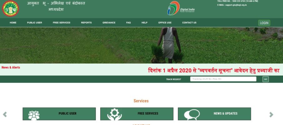
Bhu Naksha MP
For checking any bhu naksha of any land parcel or plot in Madhya Pradesh, log in on the official Bhulekh portal of MP. You can also check our comprehensive detailed way to access the MP bhulekh portal too.
The Bhu Naksha has saved the state from scams worth hundreds of crores. As the state has been burdened with these scams, and it is crucial for both buyers and sellers to complete the due diligence.
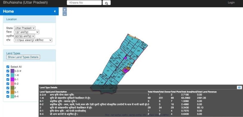
Bhu Naksha UP
Log in to the official portal of UP Bhu Naksha to find information about land parcels and plots in the state. Information that includes khatauni, khasra, details of the plot owner/s that you are planning to purchase, or the type of land on the official portal of Uttar Pradesh. For more information, you can visit their official cadastral map portal.
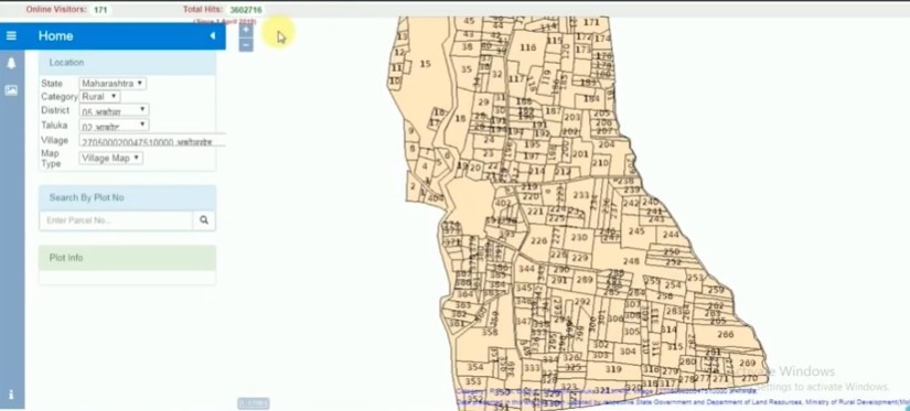
Maharashtra Bhu Naksha/Cadastral Map
The Bhu Naksha of Maharashtra is known as Mahabhunaksha. It pertains to all the relevant information of the land mapping in Maharashtra. The Mahabhunaksha is an independent platform and can be accessed through both mobile phones and desktop computers.
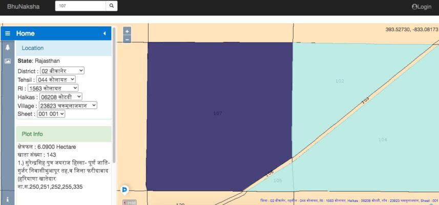
Rajasthan Bhu Naksha
Visit the official website of Rajasthan Bhu Naksha/Cadastral map to find the information about the property you are looking for in the state. For any agricultural land or parcel of land in the state, you can find all the official information about them on this site.
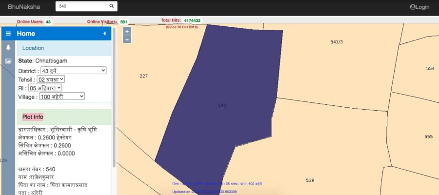
Chhattisgarh Bhu Naksha (CG Bhu Naksha)
Log in on the official portal of CG Bhu Naksha to view the cadastral map of the land. Recently, all the tehsildars and sub-divisional magistrates have been directed by the collector for the completion of cadastral maps and plans.
They are responsible for map updation within the time span of six months. This decision was taken to track every land-changes data on the ground and make it digitized for the use of the public.
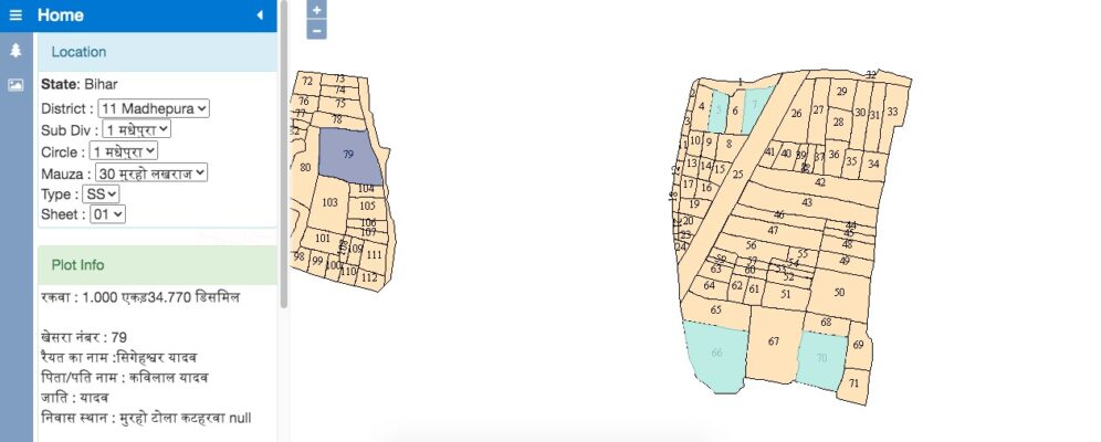
Bihar Bhu Naksha
All the information that pertains to the lands in Bihar is available on the official website of Bihar Bhu Naksha. The cadastral map meaning in Bihar is to provide the information of land to each citizen and save them from scams and frauds.
Only a few places of Bihar have set up their cadastral map that includes the places Madhepura, Nalanda, Lakhisarai, and Supaul. Only these places have the bhu naksha prepared in Bihar. For the remaining areas, the data is in the process of updating and getting digitized.
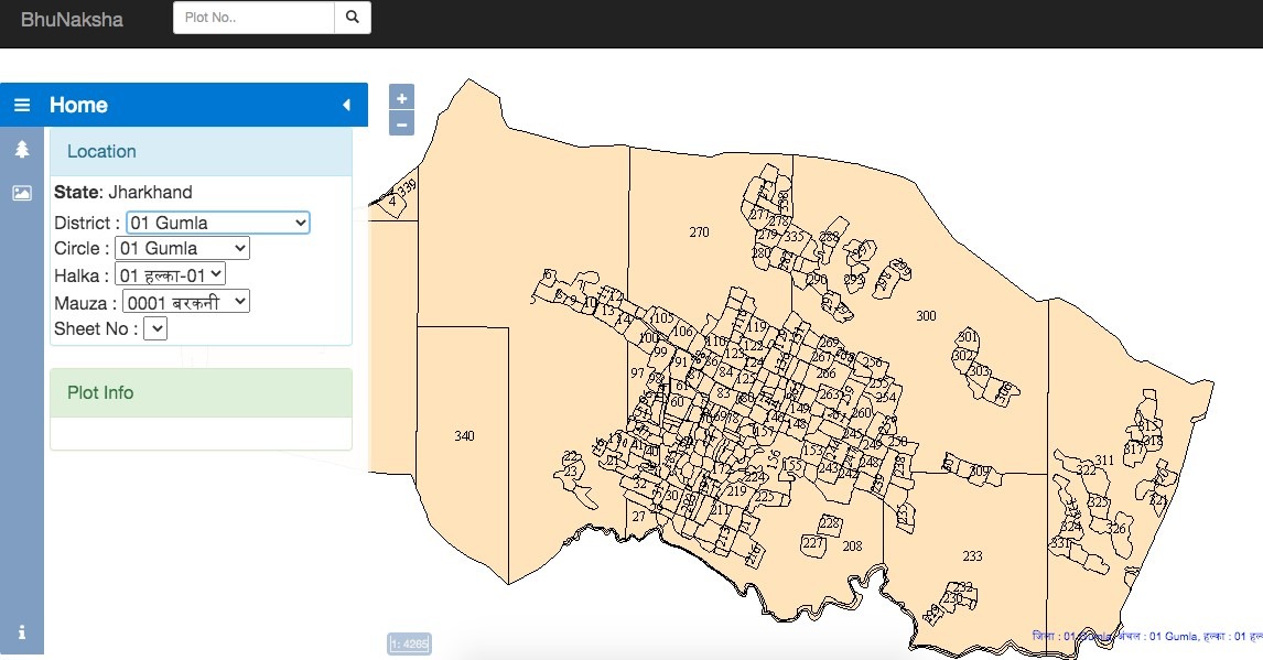
Jharkhand Bhu Naksha
All plot-mapping-related information in Jharkhand may be found on the official Bhu Naksha/ Cadastral map website of Jharkhand. A cadastral map will provide you with a detailed picture of the area and land you want to acquire. The land measurements, the sizes of the land, and the location where it is located are among the details you will receive. All of this information will be crucial in determining whether to acquire the land or not. If you’re a seller, you can download the cadastral map and deliver it to the land buyer/s. This will provide the buyer with a clear image of the property. The cadastral map of a village is also available to buyers.
Haryana Bhu Naksha
The Haryana Government has also digitized its land maps. It is done in order to help the owners of properties easily access the land records. Bhu Nakshas are digitized maps of land records.
These maps are integrated with mutation records and Records of Rights (RoR). Below is the way mentioned to view as well as download the cadastral map from the website of Jamabandi.
Step 1: Go to the official website of the Haryana Jamabandi portal. There you will find the option of the cadastral map, click on it and select the ‘View Cadastral Map’ option.
Step 2: Then, search for the cadastral map by clicking on the option of ‘Search Owner by Khewat’ or ‘Search Khasra by Owners’.
Step 3: Now, you need to enter the details of the village, tehsil, district, and the khasra number (if searching via the khasra) or enter the khewat number (if searching via the khewat).
Step 4: The portal will redirect you to the page with the information about the land. You can download the information as well.
Also Read: A Detailed Guide on Village Land Records
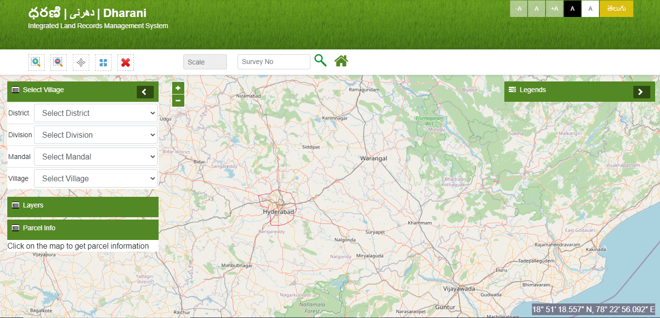
Telangana Cadastral Map
Dharani is an online portal initiated by the Telangana Government. It is an integrated platform for the management of land records. The portal enables the owners of property to view the cadastral map digitally.
Either visit the portal or click on dharani.telangana.gov.in/gis. To view the map, provide details like the name of the owner, khewat/khasra number, village, district, etc. to view the cadastral maps and plans of that region.
Plot Report – A Related Term
Plot report refers to the printable map of the plot area, i.e., the area in which the plot is located. One can scale the plot report to any size. It is because it gives a comfortable and comprehensive map view. The quality of these cadastral maps has been after the introduction of Bhu Naksha 3.0.
After hitting the print button, the cadastral map will be printed on a paper of size A4. It will be printed in the best scale fit. Also, you can add the overlay layers that would cover the plot in the name of a particular owner. In this scenario, the report of the plot map will be printed on different pages.
Need of Digitization and Updated Cadastral Maps and Plans
Various schemes have been introduced in the country on both central and state levels for the digitization of the spatial and textual records of lands. And with the same purpose, cadastral maps and plans were also introduced in India.
The NLRMP or National Land Records Modernization Programme is a scheme sponsored by the Centre government. This scheme was made after merging the two different schemes, Strengthening of Revenue Administration and Updating of Land Records (SRA & ULR) and Computerization of Land Records (CLR). It was approved in the year 2008. Further, the NLRMP has been revamped as the DILRMP or Digital India Land Records Modernization Programme.
Despite the fact that a portion of cadastral maps has been digitised, these maps do not reflect the most recent land ownership information for these parcels. Apart from the updates, the geographical and textual data remain incomplete. According to the DILRMP dashboard, about 52 per cent of geographical and textual data has been merged, and approximately 68 per cent of the cadastral map digitisation has been finished.
There is no need to keep updating or digitizing these cadastral maps and plans. As these maps are linked with the textual records of land, they will automatically provide the exact ownership details of a particular parcel of land of a region.
The digitization of records has enabled a planned development of an area while eliminating the disputes related to properties. Discussing further, the digitized cadastral maps and plans are secured and safe. It is also accessible from any corner of the world as compared to the conventional cadastral maps which are maintained on clothes.
Explore Land Records in Other States of India
| Karnataka | Bhoomi Online RTC |
| Chhattisgarh | CG Bhuiya |
| Uttarakhand | Bhulekh UK |
| Punjab | PLRS |
| Madhya Pradesh | Bhulekh MP |
| West Bengal | Banglarbhumi |
| Odisha | Bhulekh Odisha |
| Bihar | Land Record Bihar |
| Jharkhand | Jharbhoomi |
| Tamilnadu | Patta Chitta |
| Maharashtra | Mahabhulekh |
| Telangana | Dharani |
| Andhra Pradesh | Mee Bhoomi |
| Gujarat | AnyROR |
| Manipur | Loucha Pathap |
Frequently Asked Questions (FAQs)
What do cadastral maps show?
Cadastral maps and plans show the boundaries of the land subdivisions, generally with the lengths and directions of the individual tract areas.
What is the definition of a cadastral map?
A cadastral map is a large scale map that shows the land subdivision with every tract area’s boundaries, lengths, and directions.
What is a cadastral map used for?
A cadastral map is used for several different reasons. One of the most prominent reasons is to provide the public with the right land parcel information with transparency.
How is the cadastral map prepared?
For the preparation of cadastral maps, cadastral survey maps are used. For this survey, the Indian government uses satellite images of high resolution, aerial shots of areas, ground surveys with the total GPS, and the total number of stations.
What is the scale of a cadastral map?
The scale of the cadastral map can be as large as 1:4000. The scale of a cadastral map is usually between 1:500 to 1:4000.
Can I check the owner's name from bhu naksha?
Yes, the Bhu Naksha has the information about the owner of a particular land and the location information.
Are bhu naksha apps reliable?
Bhu Naksha is a government-developed application using open and free software resources. It is a reliable app that gives the correct information about land records in India.
What is bhu naksha? Is it valid?
Bhu Naksha refers to the Cadastral mapping solution in India. Yes, it is perfectly valid, and you can refer to it for land-related information.
