squareyards-logo
DataIntelligence Advertise with usNew
Sell or Rent Property
Login

Nangal Raya, Delhi

map
  • Overview
  • Why Invest?
  • How to Visit
  • Map
  • Rating & Reviews
  • Our Services
  • Blog

About Nangal Raya, Delhi

Nangal Raya is a locality in the western part of Delhi near the Delhi Cantonment area. The locality is quite congested as the population density in this area is quite high. There are parks in the area, and hence good greenery is maintained, but the roads are narrow. The locality falls between Jail Road and Pankha Road. The Pankha road connects the locality to the nearest metro station, the Dabri Mor Janakpuri South station on the Delhi Metro Railway Corporation (DMRC). The train lines through the Delhi Cantonment area are quite close to the locality, and so is the Delhi Cantonment station, so people can travel easily via local trains as well. The localities surrounding Nangal Raya are Sagarpur in the south, Mayapuri in the north, Janakpuri in the west, and Sadar bazaar in the east. 2 BHK is the most common housing configuration in this locality.
What’s on your mind askQuestion Ask and get answers from our Property Experts

Why Should You Invest in Nangal Raya, Delhi?

What’s Great About Nangal Raya
  • The locality has great connectivity to other parts of the city via Tulsidas Marg, Aishbagh Road, and Mill Road
  • New Almighty School, Brights Public School, and Maharaja Agresen Public School are located within 1km
  • Hazratganj, Janpath Bazaar, and Chowk are major commercial hubs near the locality
  • Autar Multispeciality Hospital, Rajendra Nagar Hospital, and Lucknow City Hospital are situated near the locality 
  • Industrial areas of Teai Park, Avadh, and Amausi are easily accessible from the locality
What’s Not Great About Nangal Raya
  • Waterlogging occurs during monsoons due to poor drainage system
  • Several parts of the locality are prone to vector-borne diseases, such as Dengue
  • Power cuts happen sometimes
  • Poor and inadequate water supply have been reported by the residents
  • Some roads have potholes

How to Visit Nangal Raya, Delhi?

Nangal Raya Delhi
map-icon
Please Select the destination to calculate the travel time.
Nangal Raya Map and Nearby Landmarks
map
  • Schools
  • City Connections
  • Shopping Centers
  • Business Hubs
  • Hotels
  • Hospitals
School Near by Nangal Raya
Hospital Near by Nangal Raya
Hotel Near by Nangal Raya
Shopping Center Near by Nangal Raya
City Connection Near by Nangal Raya
One-Stop Solution for all Real Estate Services Professional, white-glove property services at affordable rates
Insights & Tools
Property Rates & Price Trends

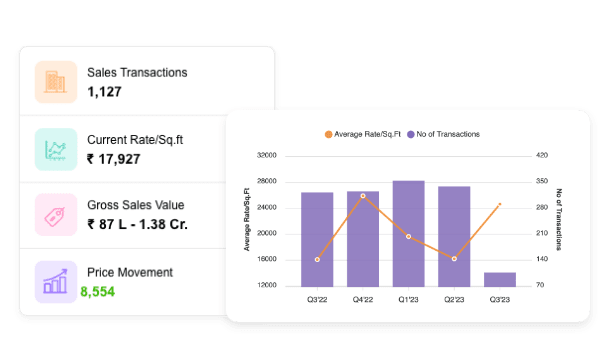
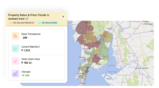
Market rates, data analytics & registered transactions of top project & localities

Property Rates & Price Trends
Explore Now
Property Rates Heatmap

An Interactive Map to help you understand a City’s Real Estate

Property Rates Heatmap
Explore Now
Valuation Report

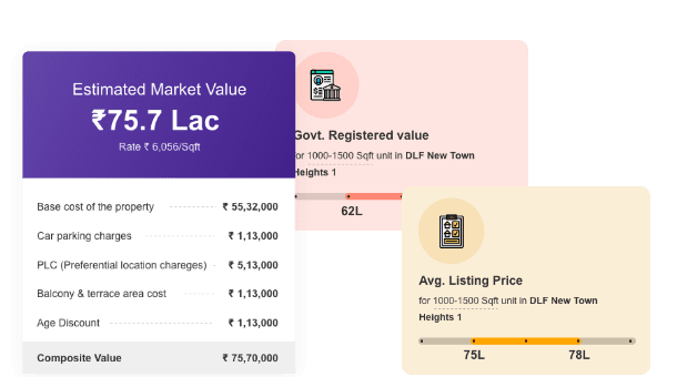
Get an instant & comprehensive Valuation Report of any property - downloadable in PDF

Valuation Report
Explore Now
Projects Reviews & Ratings

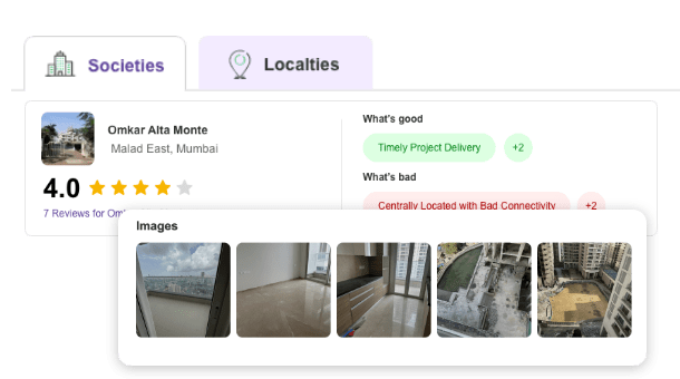
Don't just take our word for it; See what other residents, tenants & agents say about a project or locality

Reviews and Ratings
Explore Now
Nearby Localities of Nangal Raya, Delhi
Related to your search
Country/City