If you have ever tried to confirm a plot’s boundary the old way, a trip to the Talathi’s office, a request slip, a few days of waiting, you already know why Bhu Naksha Maharashtra matters. Bhu Naksha simply means land map in Hindi, and Maharashtra’s version puts every surveyed plot in the state on one searchable, satellite linked map you can open from your phone.
This guide covers what Bhu Naksha Maharashtra is, how to check your land map step by step, how to download the plot report as a PDF, how it connects to your 7/12 (Satbara) extract, what a survey number and Gat number actually mean, and answers to the exact questions people search for, district by district, in one place.
- What Is Bhu Naksha Maharashtra?
- Why Checking Your Land Map Actually Matters
- How to Check Bhu Naksha Maharashtra Online, Step by Step
- How to Check Bhu Naksha Maharashtra by Plot Number or Survey Number
- How to Download Bhu Naksha Maharashtra: Plot Report PDF
- Getting a Geo Referenced Map on Bhu Naksha Maharashtra
- Bhu Naksha vs 7/12 (Satbara) vs Property Card: What Is the Difference?
- Rural vs Urban Land: Survey Number, Gat Number and City Survey Number
- Bhu Naksha by District: Coverage Across Maharashtra
- Advantages of the Maha Bhu Naksha Portal
- Is There a Bhu Naksha Maharashtra Mobile App?
- Common Errors on the Bhu Naksha Portal and How to Fix Them
- Conclusion
What Is Bhu Naksha Maharashtra?
Bhu Naksha Maharashtra, also searched as Maha Bhu Naksha, Mahabhunakasha, Mahabhu Nakasha or Mahabhumi Naksha, is the Maharashtra government’s official cadastral mapping portal, built with the National Informatics Centre (NIC). It shows digitised land maps, plot shape, boundary lines, survey or Gat number, and area, for both rural and urban land across the state.
Think of it as the visual counterpart to your 7/12 extract. Where the 7/12, available on the Bhulekh Maharashtra portal, gives you the text record, owner name, crop details, khata number, Bhu Naksha gives you the map: where exactly that plot sits, its shape, and its neighbours.
|
Detail |
Information |
|
Official portal |
|
|
Managed by |
Maharashtra Revenue Department and NIC |
|
Cost |
Free |
|
Coverage |
All 36 districts, rural and urban |
|
Current version |
Bhunaksha 3.0 |
|
Linked service |
Bhulekh Maharashtra (7/12 and property card records) |
|
Formats available |
Online view, PDF download, print on A0, A1 or A4 |
Why Checking Your Land Map Actually Matters
Encroachments and overlapping boundary claims are among the most common reasons Indian land deals get stuck in court, and a short map check upfront can catch this before you sign anything. Bhu Naksha also cross checks the plot against government survey data, which makes it harder for someone to sell you a plot that does not match its paperwork, and banks and lawyers increasingly ask for a Bhu Naksha printout alongside the 7/12 extract during due diligence.
Beyond the legal angle, there is a simple convenience benefit too. Plot records are online and updated, so there is no need to visit a revenue office during working hours just to confirm a boundary. Bhu Naksha and the linked property card also show the landowner’s name, which helps confirm authenticity before you pay anything, whether you are a first time buyer or a bank processing a loan against the property.
How to Check Bhu Naksha Maharashtra Online, Step by Step
- Go to the official portal, mahabhunakasha.mahabhumi.gov.in.
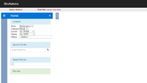
- Pick Rural or Urban land, depending on where your plot sits.
- Select District, then Taluka, then Village from the dropdown menus.
- Choose the map or sheet type and enter the survey number, or the Gat number for agricultural land, if you know it. If not, you can browse the map visually.
- Click on your plot on the map. Its details, owner name, survey number, Pot Kharaba, and area, appear in the panel next to the map.
How to Check Bhu Naksha Maharashtra by Plot Number or Survey Number
- Open the Bhu Naksha Maharashtra Portal
Visit the official Bhu Naksha portal and select the required land category. - Choose the Location
Select your District, Taluka and Village from the available options. For urban properties, choose the relevant City Survey details. - Search Using Plot or Survey Number
Enter the Plot Number or Survey/Khasra Number in the search field. You can also select the number from the available list, if shown. - Check the Plot on the Map
The selected plot will be highlighted on the map. Click on it to view the available land details, such as plot boundaries, area and other property information. - View or Download the Map Report
Select the Map Report or Show Report PDF option to view the detailed plot report. Depending on the available records, it may include details such as the area, Pot Kharaba, Khata number and owner name.
| Uttar Pradesh | Bhunaksha UP |
| Chhattisgarh | BhuNaksha CG |
| Rajasthan | BhuNaksha Rajasthan |
| Gujarat | Bhu Naksha Gujarat |
| Jharkhand | Bhu Naksha Jharkhand |
How to Download Bhu Naksha Maharashtra: Plot Report PDF
This is one of the most searched actions on this topic, so here is the exact path.
- Open mahabhunakasha.mahabhumi.gov.in and locate your plot, by district, taluka and village, or by survey number, as above.
- Once the plot details load on the left panel, click Map Report under the plot description.
- Click Show Report PDF.
- The plot report opens as a downloadable, printable PDF, showing the plot’s shape, dimensions, survey number, and neighbouring plots.
- Save it, or print it on A4, A1 or A0 paper depending on what you need it for.
Getting a Geo Referenced Map on Bhu Naksha Maharashtra
For a more technical, coordinate accurate version of the map, useful for surveyors, developers and legal verification, the portal also offers a geo referenced map view at mahabhunakasha.mahabhumi.gov.in/bhunaksha/27/georef.html. Enter your category, district, taluka and village on the left panel, then select Geo Referenced Map, and the system returns a spatially accurate map of the selected region, downloadable as a PDF. This version is closer to a true cadastral survey output than the standard plot view, and it is the one most often requested by architects, developers and legal teams during land due diligence.
Bhu Naksha vs 7/12 (Satbara) vs Property Card: What Is the Difference?
People often use Bhu Naksha, Bhulekh and 7/12 interchangeably, but they serve different purposes.
|
Document |
What it shows |
Where to get it |
|
Bhu Naksha, the land map |
Plot shape, boundaries, survey number, area, shown visually |
mahabhunakasha.mahabhumi.gov.in |
|
7/12 Extract, Satbara Utara |
Ownership, crop details, khata number, liabilities, for rural land |
bhulekh.mahabhumi.gov.in |
|
Property Card |
Urban equivalent of the 7/12, ownership and area for city or urban plots |
Same Bhulekh Maharashtra ecosystem |
|
8A Extract |
Summary of all land held by one person across survey numbers |
Bhulekh Maharashtra portal |
In short, Bhu Naksha tells you where and how big, while the 7/12 and property card tell you who owns it and under what terms. For a full property check, buyers should review both, the map first, then the corresponding record. Our detailed guide on
For a full property check, buyers should review both, the map first, then the corresponding record. Our detailed guide on Mahabhulekh Maharashtra land records walks through the 7/12 side of this in full.
Rural vs Urban Land: Survey Number, Gat Number and City Survey Number
One common point of confusion for first time users: rural agricultural land in Maharashtra is generally identified by a Gat number, a consolidated survey group number introduced to simplify fragmented rural holdings, while older records and individual parcels are tracked by survey number, and urban land uses a City Survey (CTS) number instead, maintained by the relevant municipal corporation. When you select Rural on Bhu Naksha, you are typically searching by Gat or survey number. Select Urban and you are working with the CTS number system instead. If your search returns no result, check that you selected the correct land type first, since this is the most common reason people report the portal not working.
Bhu Naksha by District: Coverage Across Maharashtra
Bhu Naksha Maharashtra covers all 36 districts, spanning both agricultural and city land. The steps described above apply identically in every district, you simply select the relevant district, taluka and village on the portal. Search demand is particularly high in a few clusters. Pune is one of the most searched districts, for both bhu naksha pune and land use map of pune, covering rural talukas as well as PMC and PCMC urban survey areas, while Nagpur searches, including bhunaksha nagpur, cover both its separate rural and city survey options. Nashik, Ahmednagar and Aurangabad, now Chhatrapati Sambhajinagar, carry large agricultural land bases with high Gat number search volume, including bhu naksha ahmednagar and bhunaksha ahmednagar, and Kolhapur, Sangli and Satara form the Western Maharashtra belt that is frequently searched together.
Thane, Mumbai City, Mumbai Suburban, Palghar and Raigad make up the Mumbai Metropolitan Region, where searches for bhu naksha mumbai, bhu naksha thane, bhu naksha palghar and bhu naksha raigad are mostly urban and CTS number based. Solapur, Latur, Nanded, Beed, Jalna, Osmanabad, Parbhani and Hingoli cover the Marathwada belt, including very specific taluka level checks such as beed patoda, while Amravati, Akola, Buldhana, Yavatmal, Washim, Wardha, Chandrapur, Gadchiroli, Bhandara, Gondia, Nandurbar, Dhule, Jalgaon, Sindhudurg and Ratnagiri round out the remaining rural and coastal districts, covering searches such as bhu naksha jalgaon, bhu naksha gondia and bhu naksha yavatmal. The full district list the portal covers is below.
|
District |
District |
|
Ahmednagar |
Nanded |
|
Amravati |
Nagpur |
|
Akola |
Nashik |
|
Aurangabad |
Nandurbar |
|
Beed |
Palghar |
|
Buldhana |
Osmanabad |
|
Bhandara |
Pune |
|
Dhule |
Parbhani |
|
Chandrapur |
Ratnagiri |
|
Gadchiroli |
Raigad |
|
Hingoli |
Satara |
|
Gondia |
Sangli |
|
Jalgaon |
Solapur |
|
Kolhapur |
Sindhudurg |
|
Jalna |
Wardha |
|
Mumbai City |
Thane |
|
Latur |
Yavatmal |
|
Mumbai Suburban |
Washim |
Maharashtra has 36 districts in total, grouped into six administrative divisions: Konkan, Pune, Nashik, Aurangabad, Amravati and Nagpur.
Advantages of the Maha Bhu Naksha Portal
The Maha Bhu Naksha portal offers a few clear advantages beyond the basic map lookup. It lets you run a legality check, spotting disputed land, government earmarked plots, or reservation issues before you invest, and it confirms accurate plot dimensions so you can be sure the boundaries and area match what is actually being sold to you. Because records are updated online, checking a plot takes minutes rather than a scheduled office visit, and the same lookup lets you cross check the seller’s name against official records for owner verification. The portal also brings the plot map and the linked Record of Rights, or ROR, details into one place, so you are not juggling two separate systems for a single property check.
Is There a Bhu Naksha Maharashtra Mobile App?
There is no official Bhu Naksha Maharashtra mobile app from the state government. Some listings and third party apps on app stores use similar names, but the only verified, government backed source is the website, mahabhunakasha.mahabhumi.gov.in, and it is mobile browser friendly, meaning it works fine on a phone without needing a separate app. If you come across an app claiming official Bhu Naksha access, treat it with caution and cross verify any data against the website directly.
Common Errors on the Bhu Naksha Portal and How to Fix Them
- No data found for your survey number: confirm you selected Rural versus Urban correctly, and that the taluka and village spelling matches the dropdown exactly.
- Map not loading or a blank screen: try a different browser, Chrome or Firefox work best, clear your cache, or check your internet connection, since the portal is map heavy and slow connections often cause partial loads.
- PDF report not generating: ensure pop ups are not blocked in your browser, since the report often opens in a new tab.
- An old survey number does not match new records: rural land re surveys sometimes update Gat numbers, so cross check with a recent 7/12 extract if an old number returns nothing.
Conclusion
Bhu Naksha Maharashtra takes what used to be a multi day, office visit process and turns it into a five minute online check. Whether you are a buyer verifying a plot before signing, a landowner confirming your boundaries, or a bank processing a loan against property, the portal, mahabhunakasha.mahabhumi.gov.in, gives you a free, government verified land map for any district in the state. Pair it with your 7/12 extract on Bhulekh Maharashtra for the complete picture, and always download the plot report PDF for your records before finalising any transaction. Since portal layouts and survey data are updated periodically, always confirm the latest details directly on the official site before relying on any screenshot or third party summary, including this one.
Frequently Asked Questions:
1. What is Bhu Naksha Maharashtra?
Bhu Naksha Maharashtra, also called Maha Bhu Naksha or Mahabhunakasha, is the state government’s free online portal for viewing land survey maps, plot boundaries and survey numbers across all 36 districts, managed with the National Informatics Centre.
2. How can I check my land map online in Maharashtra?
Visit mahabhunakasha.mahabhumi.gov.in, select Rural or Urban, choose your district, taluka and village, then click your plot on the map or enter your survey number to view its details.
3. How do I download the Bhu Naksha Maharashtra plot report as a PDF?
After locating your plot, click Map Report and then Show Report PDF. The report downloads as a printable PDF showing the plot’s boundaries, area and survey number.
4. What is the difference between Bhu Naksha and the 7/12 (Satbara) extract?
Bhu Naksha is the visual land map showing plot shape and boundaries. The 7/12 extract is the text based ownership record showing owner name, crop and khata details. Both are linked but sit on different portals.
5. Is there an official Bhu Naksha Maharashtra mobile app?
No. The Maharashtra government has not released an official Bhu Naksha app. The website is mobile friendly and works directly in any phone browser.
6. Is Bhu Naksha Maharashtra data accurate and reliable?
Yes. It is a government run, satellite linked cadastral system, updated regularly by the Revenue Department and NIC, and is recognised for verification purposes.
7. Is Bhu Naksha Maharashtra free to use?
Yes, viewing and downloading maps and plot reports on the portal is completely free.
8. What is a Gat number and how is it different from a survey number?
A Gat number is a consolidated identifier used for rural agricultural land in Maharashtra, while survey number and CTS number are used for older records and urban plots respectively. Selecting the correct land type, Rural or Urban, ensures you search the right numbering system.
9. What if my survey number shows no result on Bhu Naksha?
Check that you selected the correct land type, Rural versus Urban, and that district, taluka and village spellings match the dropdown exactly. If the land was recently re surveyed, the Gat number may have changed, so cross check against a recent 7/12 extract.
10. Can I use Bhu Naksha Maharashtra for property tax or bank loan purposes?
Yes, the plot report is commonly accepted as supporting documentation for property tax assessment and bank loan against property verification, alongside the 7/12 extract or property card.
11. How many districts does Maharashtra have?
Maharashtra has 36 districts, grouped into six administrative divisions: Konkan, Pune, Nashik, Aurangabad, Amravati and Nagpur.
12. How to download bhu naksha maharashtra?
To download the Bhu Naksha map, open the Maharashtra Bhu Naksha portal and select the required district, taluka and village. Search for the plot using its plot or survey number and select it on the map. Use the Map Report option to view the available details and download the report, if the download option is provided for the selected record.